
Free holiday dinner doubles as fundraiser as SIFPD brings Amargosa Basin communities together in Shoshone
A winter evening at the Flower Building in Shoshone became something more than a seasonal gathering on Dec. 17, as the Southern Inyo Fire Protection District (SIFPD) hosted a free community holiday dinner and party that blended celebration with a practical purpose: strengthening the local safety net through community support.
The event, held from 4 to 8 p.m., drew neighbors from across Tecopa, Shoshone, Charleston View, Death Valley Junction, Chicago Valley, and Stewart Valley. While the dinner was open to all at no cost, it carried the unmistakable imprint of a small desert region that knows how to take care of its own—especially when the institutions residents rely on are built on volunteerism and local participation.
Food anchored the night, and it arrived as a collective effort rather than a single catering line. Dishes from the area’s restaurants—Crowbar Cafe, Kit Fox Cafe, Steaks & Beer, and China A Gogo—shared the table with standout homemade tamales, turning the “dinner buffet” into a kind of edible map of the community. The atmosphere matched the menu: informal, generous, and unmistakably local.
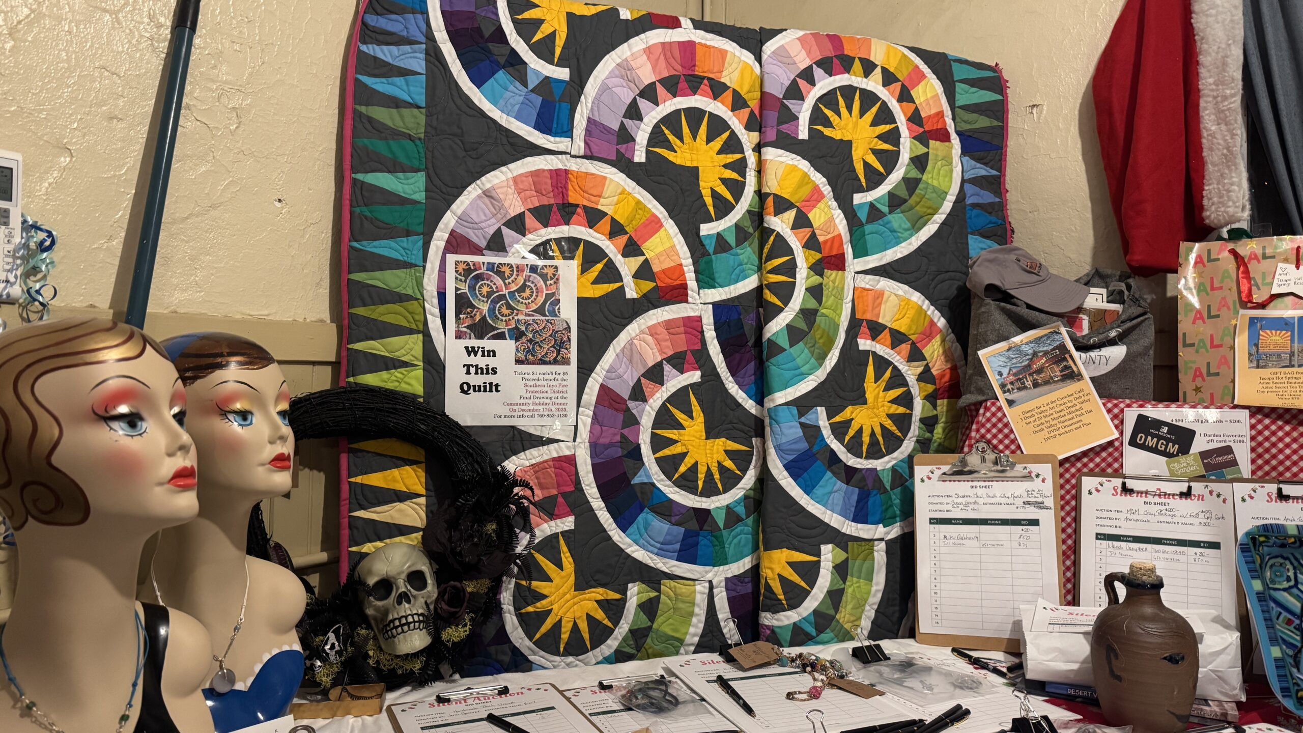
SIFPD layered in a fundraiser without making it feel transactional. Door prizes, a raffle, and a silent auction unfolded alongside the meal and music, giving attendees a way to contribute while keeping the evening’s tone firmly rooted in hospitality. One highlight of the night was the raffle quilt crafted by Marlys, which went home with winner Judy Palmer—an emblematic moment in a room full of similarly small, human-scale gestures that add up to real civic support.
Music carried the evening into its second act. With musician and singer Taps providing the soundtrack, the party shifted easily from dinner to dancing, and then into a lively stretch of karaoke that kept the crowd engaged late into the program. The result was less a formal fundraiser than a community night with a pulse—one that treated public service not as an abstract obligation but as something neighbors can actively participate in.
The holiday party was sponsored by SIFPD with support from an Inyo County community grant, a reminder that even modest public funding can travel far in rural places when it is paired with volunteer energy and local buy-in. In the Amargosa Basin, where distances are long and resources can be thin, events like this do more than lift spirits. They reinforce the relationships that make emergency response possible in the first place—relationships that can matter as much as equipment when the next call comes in.
For SIFPD, the evening’s success was measured not only in the funds raised through the auction and raffle, but in the room itself: a cross-section of the community gathered under one roof, eating food made nearby, listening to live music, and contributing—quietly, cheerfully—to the agency tasked with showing up on the hardest days.
Tecopa Community to Mark the Winter Solstice with Fire, Stars, and Shared Traditions
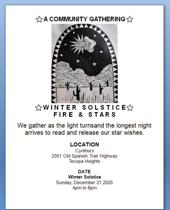

As the sun sets on the shortest day of the year, locals will gather for an intimate and celebratory Winter Solstice event that blends personal reflection, astronomical wonder, and communal warmth. Hosted at Cynthia’s home on Old Spanish Trail Highway, the December 21 gathering—titled Winter Solstice: Fire & Stars—invites neighbors to witness the turning of the season together and release “star wishes” beneath the deepening desert sky.
Organizers describe the event as a shared observance of light returning, a moment when the longest night of the year becomes an opportunity for quiet connection and renewal. Guests will begin assembling at 4 p.m. to watch the sunset and settle into the rhythm of the evening. At 4:30 p.m., attendees will take part in a solstice observance, marking the seasonal shift in whatever personal or spiritual language feels right to each participant.
By 5 p.m., the gathering moves into its ceremonial core: Fire & Stars. Hosts will light a communal fire, inviting guests to read aloud their wishes and gratitudes before releasing them to flame and night sky—a symbolic gesture of letting go and welcoming what comes next. The tradition, simple yet resonant, draws on the desert’s quiet expansiveness and its capacity to hold both memory and intention.
At 6 p.m., the focus turns upward. Mike Jerry, a local stargazing enthusiast known for his YouTube channel featuring his telescope and storytelling, will guide participants through the constellations, offering a deeper look at the stars that accompany the solstice night. Fingers crossed the night sky will cooperate, considering the current cloudy forecast.
Goodbyes are expected around 8 p.m., though the event’s open and communal nature leaves space for the evening to unfold with ease. Guests are encouraged to bring food, drink, or warmth to share—whether simple or celebratory—as an offering to the communal table. In keeping with the tone of the gathering, hosts ask attendees to arrive with kindness, curiosity, and respect. All ages are welcome.
Organizers emphasize that this is a private-property event but one grounded in inclusivity and community spirit. “Fire, sky, and company will do the rest,” reads the invitation, encapsulating a philosophy that mirrors life in the Amargosa Basin: a reliance on natural beauty, neighborly presence, and shared resilience.
For Tecopa, where the winter season settles quietly across the valley, the solstice offers not only a celestial marker but a communal pause—a moment to look inward, look outward, and look forward as the light begins its slow return.
Technology Meets the Two-Lane: New Traffic Enforcement on Highway 178 Draws Local Attention
On the long, cellular dead zone that runs between Shoshone, California and Pahrump, Nevada, the rituals of rural driving endure. When a cruiser is spotted, headlights flash from one oncoming car to the next, traveling the length of Highway 178. In a place where cell service remains aspirational, the method is part courtesy, part folklore, and wholly embedded in local culture.
Over the past several weeks, however, those courtesy flashes have taken on a new urgency as residents began reporting what they believed to be an uptick in California Highway Patrol activity. Complaints about speeding tickets circulated quickly through Chicago Valley and its neighboring communities, despite the digital silence that blankets the corridor.
But the twist, as several motorists have since learned, is that the patrol cars issuing citations are not CHP at all. The California Highway Patrol continues to have minimal presence in this corner of Inyo County. Instead, the enforcement is coming from the Inyo County Sheriff’s Office, which has quietly rolled out a refreshed fleet of vehicles and new speed-enforcement tools.
The most consequential upgrade is the introduction of lidar—light detection and ranging—speed-measurement devices. Unlike traditional radar, which sends out a wide beam and can be subject to debate when multiple vehicles are present, lidar emits a pinpoint laser capable of reading one specific car with precision. For drivers accustomed to the open, empty desert as an informal buffer, the technology marks a categorical shift.
In the far reaches of Inyo County, where law enforcement has often been defined by its scarcity, the arrival of lidar feels like a moment of modernity dropping into a place that still runs on analog habits. The sheriff’s office has not publicly announced the initiative, but motorists say the change is already felt: fewer warnings, more citations, and no ambiguity about how fast they were going.
Sources familiar with the area’s traffic patterns say vehicles can reach speeds of 80 to 95 miles per hour on the long desert straightaways, a velocity that leaves little margin for error when the highway funnels abruptly into residential sections where the posted limit drops from 65 to 35. Some residents see the stepped-up enforcement as overdue on a route where high speeds and desert conditions can be unforgiving. Others view it as an unexpected clampdown in a region where the social contract has long been shaped more by geography than by formal oversight.
Still, the flashing headlights continue—an improvised communication network that predates apps, towers, and lidar guns. On Highway 178, it remains the most reliable message one driver can send to another: something is happening in the valley. And now, with new tools in the sheriff’s arsenal, that message may matter more than ever.
Volunteers Bring Tecopa’s Mining History Back to Life as Restoration Advances at New Museum

In a corner of the Mojave where abandoned mine shafts often fade into the landscape, a group of volunteers is transforming one of Tecopa’s most precarious relics into a centerpiece of community heritage. Tecopa Mines is now in the final stages of preparing a new museum and visitor-friendly mine shaft—an ambitious undertaking that has turned a once-hazardous void in the desert into a safe, interpretive window into the region’s past.
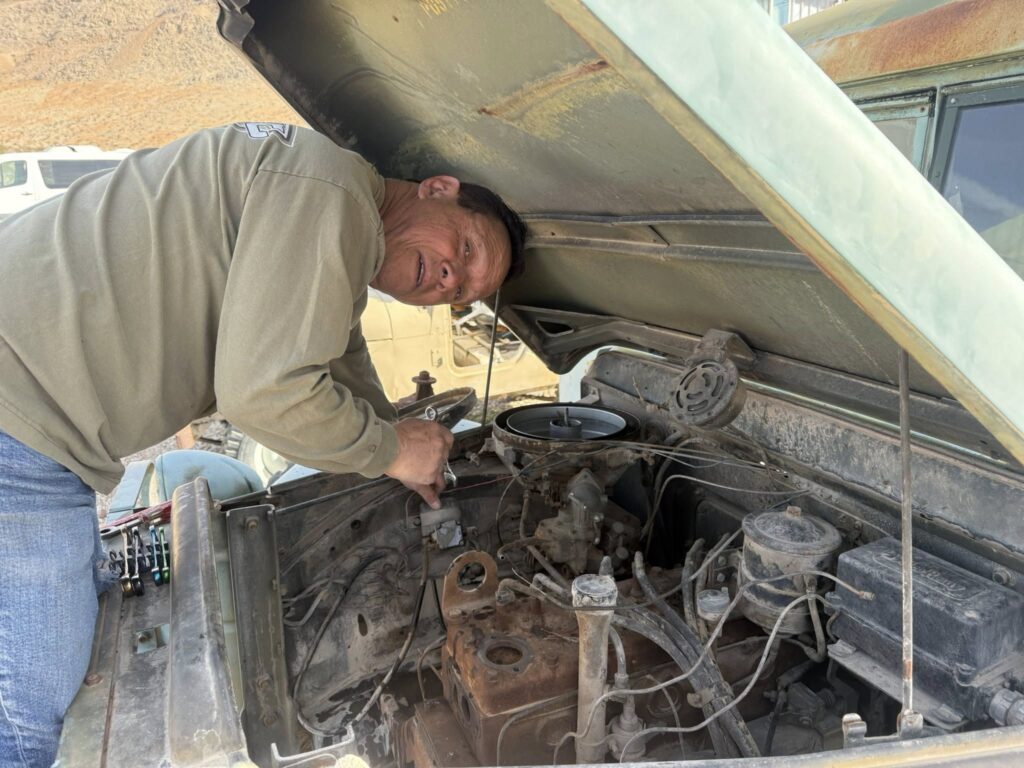
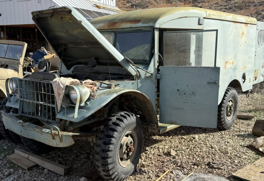
Inside the museum building, progress continues at a steady pace. “Work is still going on in the museum building; in fact, I’ve spent the day painting the floor,” said owner Ross Dykman on social media. “But while I’ve been doing that, Fritz has been working on the Dodge M43 ambulance, bringing it closer to completion. We should have another serviceable historic vehicle up here before too much longer.” The antique military ambulance is one of several period vehicles that will anchor the museum’s outdoor interpretive displays, linking Tecopa’s mining history to its broader frontier story.
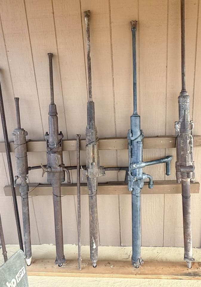
Nearby, a series of stoping drills—towering, steel-bodied tools once wielded deep underground—now stand assembled for exhibition. “Five stoping drills set up for display at the museum,” Dykman said. “Man, I’m glad I didn’t have to haul these things around underground all day as my regular job—they’re heavy! Hats off to the men who did it.” Their presence offers a tangible reminder of the physical intensity of early-20th-century mining life, an era when ore extraction demanded brute strength, precision, and a tolerance for danger.
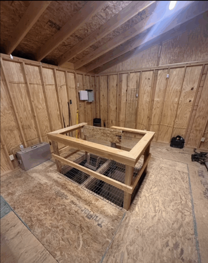
The heart of the new attraction, however, is the restored mine shaft itself—120 feet deep and more than a century old. Volunteers spent two years stabilizing the site, installing lighting, securing the perimeter, and ultimately constructing a protective building around the shaft to allow guests to safely peer into the vertical passage. The transformation required relentless labor, technical skill, and a commitment to preserving a fragile chapter of Tecopa’s history.
“It’s taken us two years to take this once very dangerous hole in the desert and clean it up, secure it, light it, and put a building around it,” Dykman said. “But it’s done, except for a few finishing touches, and ready for visitors to come and look down to see history in the Earth. The shaft is over 100 years old and 120 feet deep, and I have nothing but gratitude to the wonderful people that helped do this and to God for sending them out here.”
With final details nearly complete, the site is poised to become a new landmark for the community—a rare, hands-on encounter with the mining legacy that shaped Tecopa and the broader Amargosa Basin. For residents and visitors alike, the restored shaft offers not only a glimpse into the depths of the Earth, but a testament to what determined volunteers can build—one coat of paint, one restored vehicle, and one rescued piece of history at a time.
Record-Breaking Rains Soak Death Valley, Forming a Shallow “Lake Manly” and Closing Roads
Death Valley National Park has logged its wettest fall on record, an extraordinary turn for one of the driest places in North America and a reminder that the desert’s extremes do not end with heat.
According to the National Weather Service, the park received 2.41 inches of rain over the fall season (September through November), setting a new record for the wettest fall period. November alone delivered 1.76 inches, also a record—edging past the previous November high of 1.70 inches that stood since 1923.
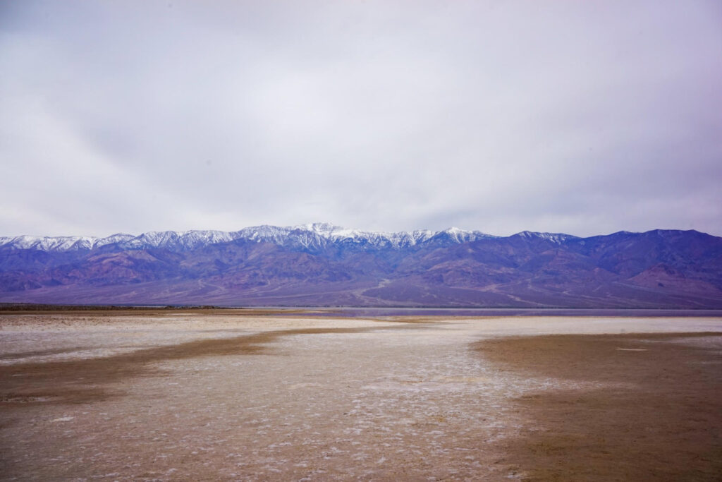
Park officials said the storms brought more rainfall than Death Valley typically receives in an entire year, reshaping familiar landscapes in subtle but striking ways. At Badwater Basin—282 feet below sea level and the lowest point in North America—rainwater has pooled into a shallow, temporary lake. The waterbody, often referred to by visitors as “Lake Manly,” sits about a mile from the Badwater parking area and, in most spots, remains only shoe-top deep.
The sight is dramatic not because of its depth, but because of its rarity: a thin sheen of water spreading across a salt flat that is more often defined by glare and dust. Still, the park emphasized that this “Lake Manly” is smaller and shallower than the more expansive version that formed after a major storm event in recent years.
The rain has also revived a perennial question that rises with every wet winter: will the spring wildflowers follow? Park staff cautioned against early certainty. While rainfall is a crucial ingredient for an above-average bloom, it is only one part of a larger recipe that includes temperature patterns, sun, wind, and the timing of storms. For now, officials say it is too early to predict whether conditions will build toward a major display comparable to the park’s standout bloom years.
Even as the landscape refreshes, the storms have left practical complications in their wake. Flood debris has forced numerous road closures across the park, including paved routes where sediment and rock have made segments impassable. Officials stressed that many of Death Valley’s signature viewpoints and attractions remain open and reachable, including Zabriskie Point, Dante’s View, Badwater Basin, and the Mesquite Sand Dunes, but warned that access can change quickly as crews assess damage and clear hazards.
Backcountry travel, in particular, demands restraint. Unpaved roads may be washed out or undermined, and conditions that appear manageable at first glance can deteriorate suddenly around bends and in narrow canyons. The park urged visitors who venture onto dirt roads to proceed with caution, carry the supplies needed to be self-sufficient, and plan for the possibility of self-rescue if routes become impassable.
For travelers, the message is straightforward: come prepared, stay flexible, and verify conditions before committing to a route. The National Park Service recommends checking the latest park updates and road status at nps.gov/deva before visiting.
After Heavy Rains, an Unidentified Shroom Steals the Spotlight at China Ranch
The Amargosa Conservancy is closing out the season with both gratitude and renewed momentum after raising more than $10,000 on Giving Tuesday—an infusion of support that leaders say will directly strengthen ongoing conservation and stewardship efforts across the Amargosa Basin.
The milestone reflects a broad base of donors who continue to see the value of protecting one of the most unique desert ecosystems in North America. From perennial springs and rare fishes to migratory bird habitat and culturally significant landscapes, the Conservancy’s work often unfolds in places that are remote, fragile, and deeply intertwined with community identity. The organization said it is “incredibly thankful” for the generosity shown this year, noting that flexible funding like Giving Tuesday contributions helps sustain fieldwork, advocacy, and restoration projects throughout the watershed.
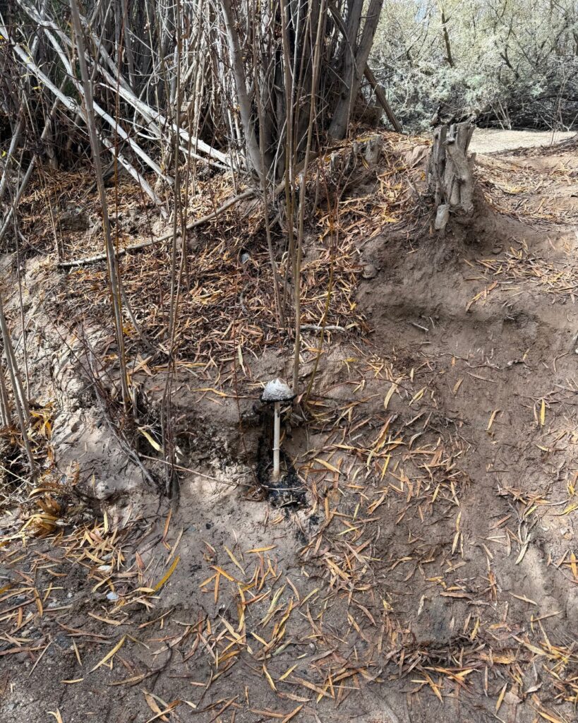
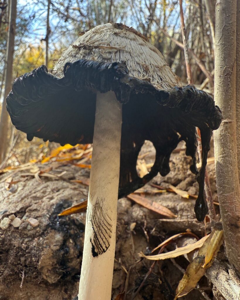
As if on cue, nature provided a reminder of that mission’s importance. In a recent post that quickly drew attention across social media, the Conservancy shared an image of a striking, unidentified mushroom found along a flowing stream at China Ranch Date Farm. The late-fall rains that transformed parts of the Amargosa Basin into ephemeral wetlands also triggered this fungal emergence—a rare sight in a landscape often defined by drought and heat.
Mushrooms are the visible reproductive structures of fungi, but the real story lies underground. The Conservancy used the discovery as an opportunity to highlight the region’s hidden mycelial networks: vast, branching systems that aerate soil, break down organic matter, and facilitate nutrient, water, and chemical exchange between plants. In riparian corridors lined with willows and mesquite, these networks may play an essential role in supporting some of the Basin’s most ecologically productive habitats.
Whether this mushroom is associated with the willows dominating that streambed—or represents a species seldom documented in the region—remains an open question. The Conservancy invited the public to help identify it, encouraging residents, naturalists, and mycology enthusiasts to share their knowledge. The post has already sparked discussion, underscoring how community science can meaningfully contribute to understanding the desert’s lesser-known ecological processes.
Early guesses in the comments have centered on two possibilities: an ink cap (Coprinus or Coprinellus species) or the closely related Shaggy Mane (Coprinus comatus). Both are part of a group of fungi known for their delicate gills and tendency to “deliquesce”—dissolve into a black, inky liquid as they mature. While neither is commonly associated with the Mojave Desert, they can emerge briefly in wet cycles, especially after the kind of heavy November rains that saturated stream channels across the Basin.
The mushroom discovery comes at a moment when China Ranch itself is enjoying a wave of regional attention. The November/December issue of Pahrump Life Magazine featured owner Brian Brown and manager Christy Horne on its cover, accompanied by a detailed profile tracing the ranch’s unlikely history—from a remote, rugged homestead to one of the Amargosa region’s most recognizable agricultural landmarks. The article highlighted the ranch’s more than 1,000 date trees, representing 12 distinct varieties, all of which are pollinated by hand—a labor-intensive practice that preserves both the quality and lineage of the orchard. The feature underscored China Ranch’s role not only as a cherished local destination but also as a living demonstration of how careful stewardship can sustain productivity in a challenging desert landscape.
As winter approaches, the twin stories—one of a generous public rallying behind conservation, the other of a mysterious organism rising from saturated soils—capture the spirit of the Amargosa Basin: resilient, interconnected, and full of discoveries still waiting to be made.
Leave a Reply